Start: Green Mountains
Class 4
17.4km rtn (my GPS tagged it as 22k)
Approx 6hrs
After Confirming my Masters on Friday (which basically means the university like the project and I can continue for a bit longer) I took off on Wednesday at 6:30am, deciding I had enough time to do one of the day walks. Problem I have is getting though first the Brisbane traffic then hitting the Gold Coast right at peak time. It took me over 2 hours to get to the Green Mountains (which are another 30-odd km farther along than Binna Burra). Something to think about when it comes to the long day walks like Ship’s Stern and Mt Hobwee.
Easy drive up, though we had a very nasty little storm come through on Monday, and I wonder if it loosened things up a bit as there were a lot of rockfalls on the mountain roads. Nothing too dramatic. O’Reilly’s was pretty empty, but then it was midweek.
I’ve not walked the Toolona Circuit before. It’s a creek track, following the crease of a gorge, bisecting two points of the Border Track (which spines so many walks here). So it starts on the Border, first on wide wooden decking, then graded gravel. The sheer number of visitors here means damage mitigation is essential, especially considering the beginning of the Border Track leads to the famous Airwalk and then on to the botanic gardens. That’s a lot of feet.
I dip off the Border at the start of the twisty little Box Forest Circuit. Still graded and easy to follow. It’s a stunning day, not a cloud above and the light through the canopy is equally soft and shattered. Oh, I have new boots as well. After much research, I picked up a pair of Scarpa Cyrus gtx. Lovely, lightweight (but still mostly leather) Gore-Tex lined stomping machines that are funky enough that I can wear them around town. I mentioned in the post before that my Deltas are just too big and heavy for 99% of the conditions in Queensland. Well these should be perfect for here and the large amount of urban walking I do (and no I’m not being sponsored by anyone).
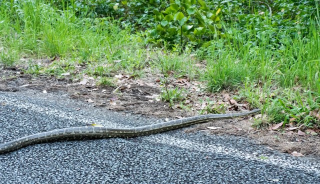
First stop of the day is Picnic Rock, which is at the top of Elabana Falls. There’s actually not a lot to see here, the real spot is below, following a switchback and a slight detour. It’s here that I walked over the Red-Bellied Black Snake. Funny thing is, I did actually see it, but it’s been such a long time since I’d seen snake in here that my first thought was one of annoyance that someone had dropped a child’s plastic toy on the path. Then, of course, it moved. It was only a small one, maybe a metre and a bit long, and quite sluggish as it was a fairly shady path. Beautiful though, and silent as it melted back into the green.


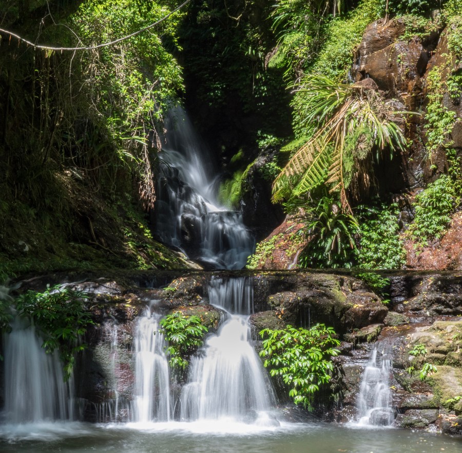
Elabana Falls is the picture postcard waterfall of Lamington. I’m looking at a photo of it now, on the map cover. I’ve not been here for a good few years but it’s barely changed (I suppose it wouldn’t, really). I mooch around, taking a few photos. It’s nice to have the place to myself. There’s a surprising amount of crap around. Lolly wrappers, orange peel, and, most alarmingly, little clumps of white toilet paper right next to the water course.

I return to the switchback, and the Toolona Track starts proper. As I mentioned before, this is a creek track, so it’s winding, steep, damp and overgrown. Excellent. I’m not going to list all the waterfalls (there’s around 15), and as it’s a pretty steep gorge, so some of them are pretty high. Birdlife is everywhere, and there’s also a surprising amount of potaroos around, darting off into the scrub, usually nothing much more than little explosions of chaos. I’m the first one through here, at least for today, if not longer. The track is criss-crossed with cobwebs that I break though, mummifying me by microns at a time. The ground is damp, but not really muddy, and through the creek is flowing nicely, it does look a little low. Still, we are coming off the dry season. I imagine in full flood this gorge would be a cacophony.


It’s an interesting path. It crosses the stream, doubles back on itself, wanders precariously up the side of the gorge then seems to change its mind heads back over the stream. There’s only one moment of confusion, where a blaze points in a vague direction, but a moment of looking around carefully, I spotted the other blaze, across the water, and upon further investigation I found the track ambling upwards again. Mentally, it’s an easy path to lose yourself on, especially if you’re a photographer. The only time I came to physical grief was because of a fresh deadfall. Now, sometimes these are as simple as hopping over (or under) a trunk, but this one… it was basically like working my way through a horizontal tree canopy, complete with a slick, mossy 1.5m thick trunk. I managed to skin my hands, slipping as I straddled the wood (I imagine the sight would have been a bit amusing). Eventually I had to discard my backpack (filled with camera, lenses, tripod and lunch) to wiggle through a gap. All good fun, if a bit messy.


So there’s one thing that happened on the track that I wasn’t sure I was going to write about until just now.If you’re a bit squeamish about bodily functions, skip down until you see the happy photo of the bird. So I’m walking along a relatively flat and level section, boxed in by trees and scrubby bushes, but not that close, pressed atmosphere of the gorge, when I come across a shit. Believe me, I sat here tying to think how best to describe this, but in all reality, it was a huge, human shit. On a rock. On the path. Few days old I guess (bit I’m no expert). There were no attempts to hide it (not even paper or leaves), it was just on a rock that was part of the trail edging. At first I was simply revolted, but as I walked on, I found myself dwelling on it a lot (which is nothing new as my mind turns in on itself when I walk and simple ideas become internalised epics). This wasn’t just somebody caught short, I mean that happens to all of us at some point on a day-long hike. This was a statement shit. I mean, who does that? I’m 10km into the rainforest here, with at least another 7km to go, so we’re not talking about a casual visitor wearing thongs and being a wanker.
I just don’t get it. I don’t understand the mentality behind someone who would do that.
It’s bad enough that on the walks within 5km of the start zones if you stop at a waterfall or a viewpoint, there’s inevitably piles of toilet paper crammed into rocks, behind a tree, or simply just left within a step or two of the path. I realise that they’re stopping points, and if someone is going to feel the urge, it’ll be then, but fuck… I see it everywhere now. I understand most people don’t walk with a trowel, but how fucking hard is it to bury crap, or at least cover it over far enough away from the track (and waterways) so that people don’t have to see it. I just don’t get it. It’s a World Heritage Site, and other than that pretty important title, it’s a fucking magical place, an inspirational place. I would never drink from the waterways in this park unless I was very deep, and even then I’d boil the hell out of it. I don’t have any answers. I’m not sure that there are any really.
Ok, back to the track, though I imagine the balance between tourism, access and environmental damage is something I’ll have to revisit again.


The switchbacks are a bit more frequent (and there’s a special place in Hell for people who shortcut them and score ugly great eroded gashes in the hillside. Right, I promise that’s my last grouch for today). Looking at the map I can see I only have a few more waterfalls left, so at each one I shed my pack and hop around with rock pools looking for a Lamington Spiny Crayfish. These bright blue crustaceans can get to over 13cm in length, and are sometimes found wandering the paths in the rain, hissing and waving their claws at people. I was lucky enough to have a huge one walk over my boot while I was resting on one of my very first trips here, and I was eager to find some more. At the third set of pools, I managed to find a couple of smaller ones (4cm or so). Damn they move quick in the water. I tried to get a photo, but surprisingly the vivid blue didn’t show up too well against the mud of the pools. Another time.
So, out of the gorge and up onto the Border Track. The Toolona Lookout offers a view all the way to the sea in NSW. It’s a lovely clear day and I can even see the white frosting of breakers. Mt Toolona is just off the right, and caps out at 1189m, which is quite respectable for around here. The Border Track is easy, flat and simple to follow (which is lucky as there have been a couple of times when I’ve misjudged how much I fart around with my cameras and have had to walk out in the near-dark). The stands of Antarctic Beeches are just beautiful. They seep age. Lamington contains the most northerly stands of these amazing trees. Whereas the leaves of the Tasmanian ones I walked on recently were small, like pistachio shells, these are broad like the ones in England, though the trunks, seemingly dying from the inside out, remind me more of the colossal grandfather Oaks that dot Hayes Common in my native Kent.

No real surprises along the Border, although it is a fair bit muddier than I expected it to be and the boots get a bit of a workout. I’ve still not seem another person on this walk. Bliss.


The closer I get to the end, the more abundant the birdlife becomes, and as I emerge back into O’Reilly’s, I bump into a group of photographers making the most of the wildlife. There was a time when I would have envied those lenses the length of my arm, but after walking 80-odd kilometres of the Overland Track in Tassie carrying heavy glass and a big DSLR, I’m so glad I traded for this Olympus system.
After how tired I was driving home last time, I’d made myself a flask of coffee. It was magic just sitting on the grass watching the birds and unwinding. But one final surprise was waiting for me down near the car…